

FLOOD WARNING “IFLOWS-Mumbai”
FLOOD WARNING SYSTEM FOR MUMBAI “IFLOWS-Mumbai” to be launched on June 12, 2020
FLOOD WARNING “IFLOWS-Mumbai”
New Delhi: Maharasthra Chief Minister Uddhav Thackeray and Dr Harsh Vardhan, Union Minister for Health & Family Welfare, Science & Technology, Earth Sciences will launch the Flood Warning System for Mumbai on June 12.
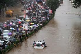
Mumbai has been experiencing floods with increased periodicity and recent flood in 29 August 2017, brought the city to a standstill. The flood during 26th July 2005, is probably etched in the memory of every Mumbai citizen, when the city received a rainfall of 94cm, a 100 year high in a span of 24 hours paralyzing the city completely.
FLOOD WARNING “IFLOWS-Mumbai”
In a bid to aid in the mitigation activities of the flood prone city, Municipal Corporation of Greater Mumbai, Govt of Maharashtra approached the Ministry of Earth Sciences (MoES) to develop an Integrated Flood Warning System for Mumbai referred to as, IFLOWS-Mumbai. MoES initiated the development of IFLOWS-Mumbai in July 2019 using the in-house expertise available within the Ministry of Earth Sciences in close coordination with Municipal Corporation of Greater Mumbai. IFLOWS-Mumbai is developed as a state of art Integrated Flood Warning system for Mumbai to enhance the resilience of the city of Mumbai by providing early warning for flooding specially during high rainfall events and cyclones.
FLOOD WARNING “IFLOWS-Mumbai”
I-FLOWS is built on a modular structure and comprises of seven modules, namely Data Assimilation, Flood, Inundation, Vulnerability, Risk, Dissemination Module and Decision Support System. The system incorporates weather models from National Centre for medium Range Weather Forecasting (NCMRWF), India Meteorological Department (IMD), field data from the rain gauge network stations setup by Indian Institute of Tropical Meteorology (IITM), Municipal Corporation of Greater Mumbai (MCGM) and IMD, thematic layers on land use, infrastructure etc provided by MCGM. Based on inputs from weather models, Hydrologic models are used to transform rainfall into runoff and provides inflow inputs into the river systems. Hydraulic models are used to solve equations of fluid motion to replicate the movement of water to assess flooding in the study area. Since, Mumbai is an island city with its connectivity to sea, hydrodynamic models and storm surge model are used to calculate the tide and storm surge impacts on the city.
FLOOD WARNING “IFLOWS-Mumbai”
The system has provisions to capture the urban drainage within the city and predict the areas of flooding, which will be incorporated in the final system. The data on river bathymetry was collected in all rivers namely Mithi, Dahisar, Oshiwara, Poisar, Ulhas, lakes and creeks by NCCR in association with MCGM and IMD, Mumbai. The land topography, land use, infrastructure, population etc., was provided by MCGM and it was integrated into a Decision Support System to accurately estimate flood levels at ward level using thematic layers in GIS. A web GIS based decision supports system is built to calculate the vulnerability and risk of elements exposed to flood.